¶ Heraklion Airport
The information in this document is not intended for real aviation. It is only intended for computer-based flight simulation.
Heraklion Airport (LGIR/HER) is the primary airport of the island of Crete, a very popular summer tourist destination. It is located just outside Heraklion, the capital of Crete, on the north coast of the island – and is named after Nikos Kazantzakis, a Greek writer, author of the world-famous Zorba the Greek novel. In several years, the airport will be replaced by the new Kasteli International Airport, which is being built about 20 kilometers southeast of LGIR.
This document summarizes essential information you should know for a realistic flight simulator experience.
For more information, please refer to the real-life Aeronautical Information Publication (AIP):
https://aisgr.hasp.gov.gr
¶ Scenery
Recommended LGIR scenery for MSFS:
JustSim - payware
JasonGR - freeware
Recommended LGIR scenery for X-Plane:
FlyTampa - payware
tdg - freeware
Recommended LGIR scenery for P3D:
JustSim - payware
¶ Arrival
The airport has two runways – 09/27 and 12/30.
Runway 09/27 (length 2714 m, width 45 m) is the main runway, providing for almost all commercial aircraft operations at LGIR. Due to the prevailing winds, runway 27 is in use in most cases.
Runway 12/30 (length 1566 m) is only used for up to code letter B aircraft. Larger aircraft (including B737 and A320, which are code letter C aircraft) are not allowed to use runway 12/30.
Terrain rises steeply west and south of the airport.
Severe turbulence on final approach can be expected if the winds blow from the south or south-west at speeds of 20 knots or more. Windshear and downdraft can be expected if the winds blow from the north at speeds of 10 knots or more.
A parallel taxiway is available for almost the entire length of the runway, except for the last 500 meters of RWY 27 – but you will likely be able to vacate the runway before that. Turn pads are available at both ends of the runway.
Taxiing must be carried out using only the minimum possible thrust and at low speed. In the real life, all aircraft are guided to their stands with follow-me cars.
¶ Runway 09 Approach
There are no straight-in instrument approach procedures to this runway.
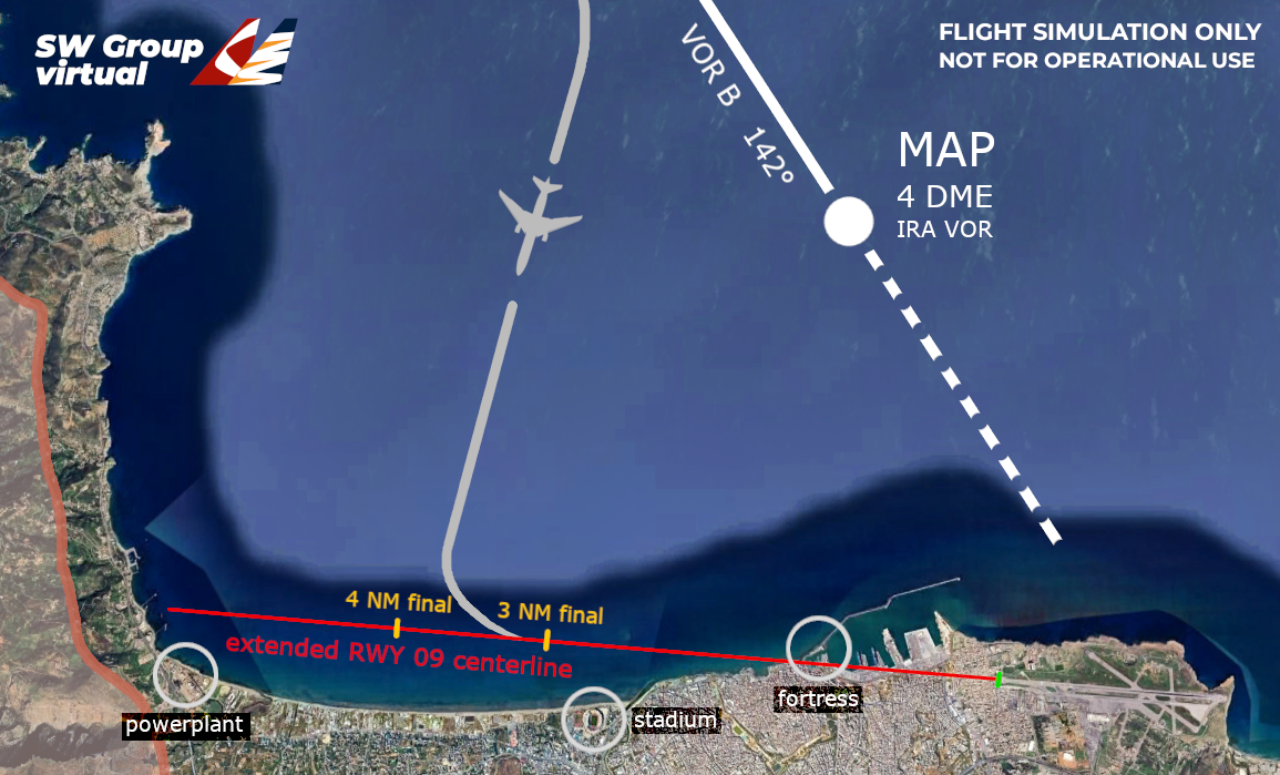
The preferred approach procedure for runway 09 is VOR-B. However, pilots are expected to switch to visual approach as soon as the runway is in sight, provided that terrain clearance can be maintained visually. Transition to visual approach can be done at the latest on reaching MAP (Missed Approach Point - 4 NM from IRA VOR), preferably before.
It is recommended that aircraft join final runway 09 between 4 to 3 NM from runway threshold.
For visual reference, several significant objects on the coastline may be used as visual cues: a powerplant, a stadium at the edge of the city, and a fortress in the port.
There are no prescribed tracks for this visual maneuver. The image below shows an example of a visual approach towards RWY 09.
Runway 09 threshold is displaced by about 500 meters.
If you wish to fly a RWY 27 approach and then perform a circle-to-land procedure towards RWY 09, the maneuver must be performed north of the runway.
¶ Runway 27 Approach
Runway 27 will very likely be in use when you visit this airport, as the wind here usually blows from the west.
The preferred approach procedure is RNP 27. Visual approach is possible, but the airport is usually quite busy, and ATC may prefer aircraft to adhere to published procedures.
Do not deviate south of the extended runway 27 centerline, due to the presence of a high mountain range. If you wish to perform a circle-to-land procedure towards runway 09, the maneuver must be performed north of the runway.
It is recommended to select approach speet of at least VREF + 10 knots, as the wind may significantly vary due to a steep ridge rising from the sea directly before RWY 27 threshold.
The RNP descent path has a gradient of 3.4°, and the VOR descent path is 3.32° – however, the PAPI lights angle is 3°. Keep in mind that the PAPI lights will indicate that you are too high.
When approaching RWY 27, take note that the first part of the runway feature a significant up-slope. This may lead to the illusion that the aircraft is too high, and you may descend below the correct glide path.
The terrain shortly before the threshold of RWY 27 rises almost vertically from the sea to about 80 feet. The GPWS altitude callouts will be affected by this: if on the correct glide path, be prepared that "100" feet callout may be completely skipped.
The terrain rises steeply about 6 NM behind the runway. If a missed approach is performed, a right turn is necessary to avoid terrain.
Taxiways C, B or A are typically used for vacating the runway. Taxiway C has a considerable up-slope.
¶ Departure
On most stands at LGIR, no pushback is used. Stands number 1 to 15 are self-maneuvering, and the aircraft leaves the stand by taxiing forward under its own power.
Crossbleed starts are permitted only on stands 11, 12, 14 and 15. If the aircraft is parked at any other parking position and a crossbleed start is required, it is necessary to start one engine using the ASU (Air Starter Unit), taxi out on TWY D, turn into the direction of taxiing, stop, and only then start the second engine.
When flying online, remember to request startup and taxi clearance only if the maneuver can be performed immediately. Apron and taxiway space at LGIR is limited. The aircraft is expected to be able to taxi within 10 minutes from requesting startup clearance.
Taxiing must be carried out using only the minimum possible thrust and at low speed.
Although runway 12/30 is not used much, it still is an active runway. When flying online, do not cross this runway without clearance.
Severe turbulence on departure can be expected if the winds blow from the south or south-west at speeds of 20 knots or more.