¶ Samos Airport
The information in this document is not intended for real aviation. It is only intended for computer-based flight simulation.
Samos Airport (LGSM/SMI) is located on the coast of the same named island in the Aegean Sea, and is surrounded by high terrain from one side, and by the border of Greek airspace on the other side. A "straight-in" approach is not possible from neither side, and a visual circling approach has to be performed.
This document summarizes essential information you should know for a realistic flight simulator experience.
For more information, please refer to the real-life Aeronautical Information Publication (AIP):
https://aisgr.hasp.gov.gr
¶ Scenery
Recommended LGSM scenery for MSFS:
ORBX - payware
AlexAb - freeware
Recommended LGSM scenery for X-Plane:
Skyline Simulations - payware
tdg - freeware
Recommended LGSM scenery for Prepar3D:
29Palms - payware
George Keogh - freeware
¶ Arrival - RWY 09
Due to prevailing winds, it is very likely that runway 09 will be in use on your arrival. The following text describes the procedure for flying a visual approach to RWY 09, including coordinates for creating custom waypoints and screenshots for visual reference.
The recommended landing configuration (for B737) is Flaps 30/40, Autobrake 3, Full thrust reversers.
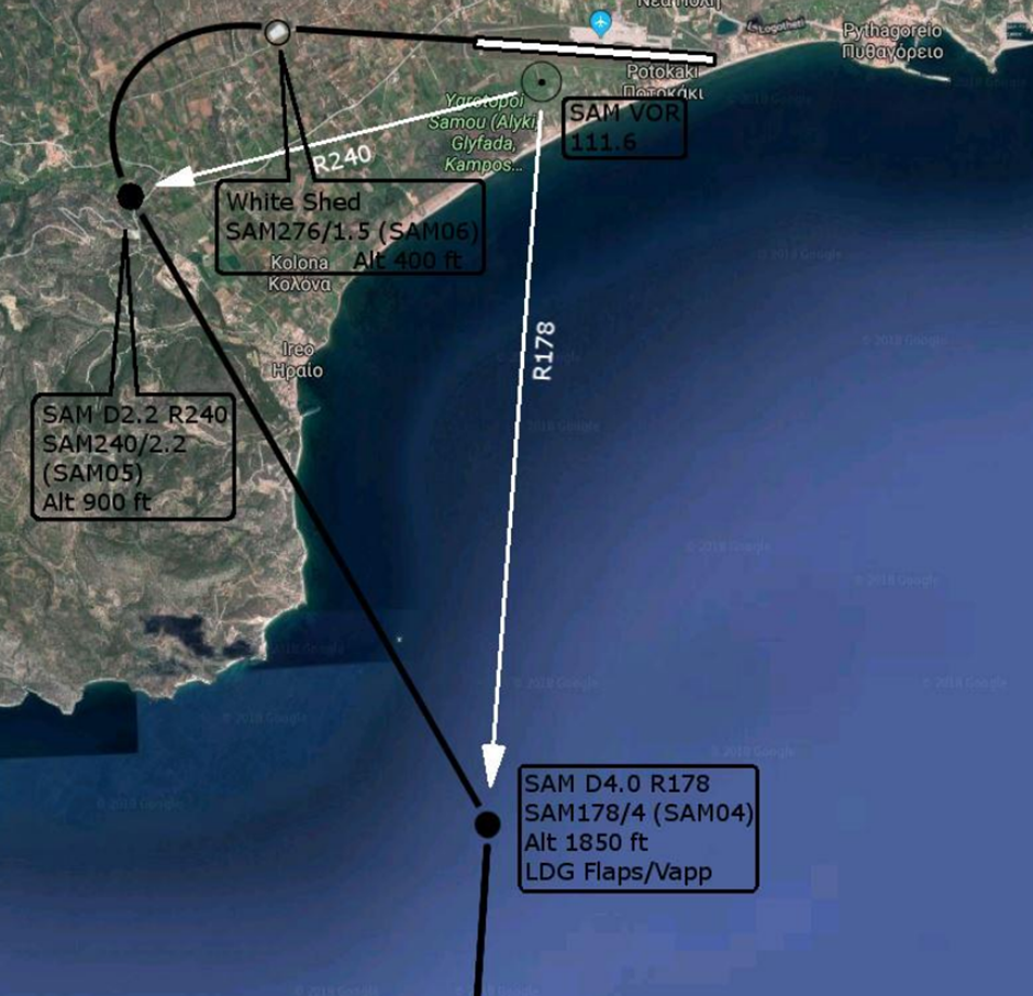
The following table shows the significant reference points when visually approaching runway 09, as shown in the diagram on the previous page. The "custom WPT" column indicates the exact form for entering a custom waypoint into the FMS B737.
| RW09 | coordinates | custom WPT | altitude |
|---|---|---|---|
| WPT 1 | SAM D4.0 R178 | SAM178/4 | 1850 ft |
| WPT 2 | SAM D2.2 R240 | SAM240/2.2 | 900 ft |
| WPT 3 | SAM D1.5 R276 ("white shed") | SAM276/1.5 | 400 ft |
On the navigation display, the entered waypoints will appear as follows:
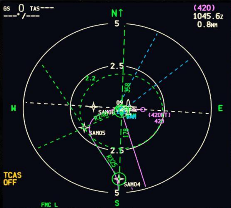
Configure the aircraft to full landing configuration before reaching D4.0 SAM (4 nm from SAM VOR/DME).
We recommend switching the autopilot back to LNAV/VNAV mode, if custom waypoints are entered: the Flight Director will continue to give instructions after the autopilot is disconnected, which is useful given the restrictive cockpit view in the simulator environment.
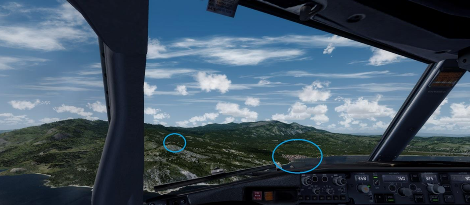
On reaching the D4.0 SAM at 1850 ft, turn left onto heading 325 and continue descending. Visually we can orient ourselves by the village on the coast with the pier on the right, and the elevated terrain with lighthouses on the left. We should be heading between the village and the lighthouses (see screenshot).
We continue descending on heading 325 until passing SAM VOR/DME radial 240. At this point we should be at 900 ft. We will enter a right turn bank of 25° to 30° on final RWY 09.
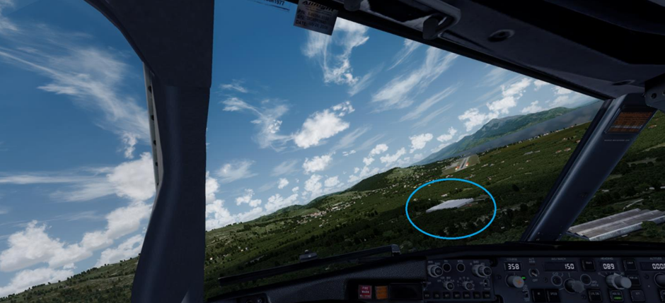
Final should be reached at 400 ft above a distinct large shed with a white roof (see screenshot).
¶ Arrival - RWY 27
Due to prevailing winds, it is very likely that runway 09 will be in use on your arrival. An approach to runway 27 is also possible, but due to the terrain in the vicinity, strong wind gusts and wind shear can be expected. The entire approach to runway 27 is done over the sea, so there are fewer reference points.
The recommended landing configuration (for B737) is Flaps 30/40, Autobrake 3, Full thrust reversers.
The following table shows the significant reference points when visually approaching runway 27, as shown in the diagram on the previous page. The "custom WPT" column indicates the exact form for entering a custom waypoint into the FMS B737.
| RW27 | coordinates | custom WPT | altitude |
|---|---|---|---|
| WPT 1 | SAM D4.0 R178 | SAM178/4 | 1850 ft |
| WPT 2 | SAM D2.2 R120 | SAM120/2.2 | 900 ft |
| WPT 3 | SAM D1.5 R096 ("pier") | SAM096/1.5 | 400 ft |
Configure the aircraft to full landing configuration before reaching D4.0 SAM (4 nm from SAM VOR/DME).
We recommend switching the autopilot back to LNAV/VNAV mode, if custom waypoints are entered: the Flight Director will continue to give instructions after the autopilot is disconnected, which is useful given the restrictive cockpit view in the simulator environment.
Upon reaching D4.0 SAM at 1850 ft, initiate a right turn to heading 040. Continue on this heading while descending steadily until passing radial 120 from the SAM VOR/DME. At this point we should have an altitude of 900 ft. Initiate a left turn for final RWY 27.
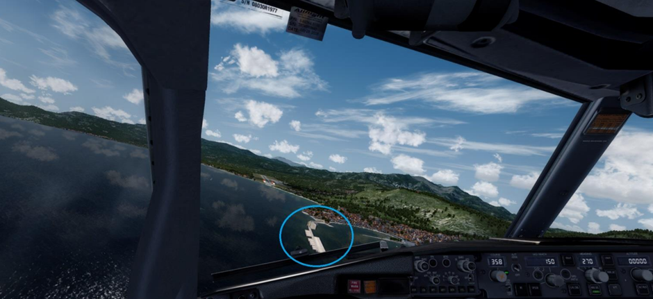
Final should be reached at 400 ft above a harbour pier on the coast (see screenshot).
¶ Departure
During winter season (November to April), aircraft may park parallel to the terminal regardless of marked parking positions.
Pushback is used at the airport. The direction of pushback is determined by the runway in use: if runway 09 is in use, the aircraft will be facing west, and vice versa.
Crossbleed starting is not allowed on stand. It is mandatory to only start one engine on stand using the air starter unit (ASU), and to start the other engine only after pushing out on taxiway A.
At Samos, the transponder is switched on before the first movement of the aircraft.
If strong northerly winds (over 20 kt) prevail, wind shear can be expected on takeoff.
Departure procedures, like arrival procedures, reflect the proximity of the high mountains on the west side, and the boundaries of Greek airspace on the east side of the airport. Departure in either direction requires a visual turn shortly after takeoff.
In the real world, the island is home to the Yellow-legged gull. Particularly in spring and in rainy weather, an intense presence of these birds is observed in close proximity to the airport, usually in flocks of 30 to 50 birds.